
Written by Julia Rojas-Contento, volunteer writer
Growing up in the St. Clair West Village neighbourhood, I have been fortunate to have access to various forms of sustainable transportation. I can take multiple buses that all lead to subway lines or the St. Clair streetcar, plus there are bike lanes and wide sidewalks to keep me safe when I’m cycling or on foot.
It must also be noted that my neighbourhood is considered predominantly middle-class and white, with a large percentage of households with Italian and Portuguese backgrounds.
Like most older neighbourhoods close to the downtown core, Walkscore.com gives my neighbourhood high scores for walking, transit and cycling, which means that most trips do not require a car and it’s easy to get around by foot, on transit, or by bike.
Unfortunately, this isn’t the case across the entire city. Many of Toronto’s lower-income and racialized neighbourhoods are not as well-connected and can be considered transit deserts.
A transit desert is similar to the concept of a food desert. In both cases, the relationship between neighbourhood demographics, public and private policies and geographic form impact the neigbhbourhood’s access to transit or food resources. Transit deserts are areas that have limited access to transportation supply and are often areas farther away from the urban core, in communities with higher percentage of residents who are Black, Indigenous, People of Colour (BIPOC).
Key indicators of a transit desert include areas where subway and rapid-transit options are insufficient, bus routes are under-resourced, residents have to walk a longer distance to the nearest transit hub and there is poor bike, sidewalk, or road infrastructure.
The Martin Prosperity Institute gave Toronto neighbourhoods a ranking score based on their access to public transportation from 0 to 1,500. Scarborough’s average neighbourhood score sat at 20.97, whereas more affluent neighbourhoods in the city scored an average of 102.8 in transit access and connectivity. The scoring of neighbourhoods provides a clear idea of the link between transit deserts and lower-income, racialized neighbourhoods.
These inequities have become especially visible this year, with northwest Toronto reporting higher cases of COVID-19 compared to more affluent areas of the city. This area of the city is not as well connected as other neighbourhoods and has a higher percentage of low-income and BIPOC residents, many of whom rely on crowded TTC buses to get to work.
If transit routes are sparse or unreliable, cycling could be a good option to get around, but unfortunately areas that are classified as transit deserts also tend to be areas where cycling is also more difficult.
Transit deserts tend to be areas where the infrastructure is not designed for modes of transportation other than driving, with more road space than sidewalk space and a lack of safe bike routes.
Toronto Cycling Think and Do Tank’s ‘Mapping Cycling Behaviour in Toronto’ analysis outlines the significance of location when viewing patterns of cycling behaviour and usage. Through their analysis it became clear that the highest percentage of cyclists live and work within the Toronto downtown boundaries, with an extremely low percentage of users living and working in outer city wards.
The Map of Cycling behaviour corresponds with David Hulchanski’s ‘Three Cities Within Toronto’ map, where Hulchanski uses data over the span of 30 years to map out the different polarized socio-economic areas within the City of Toronto – City #1 (high-income), City #2 (middle-income) and City #3 (low-income).
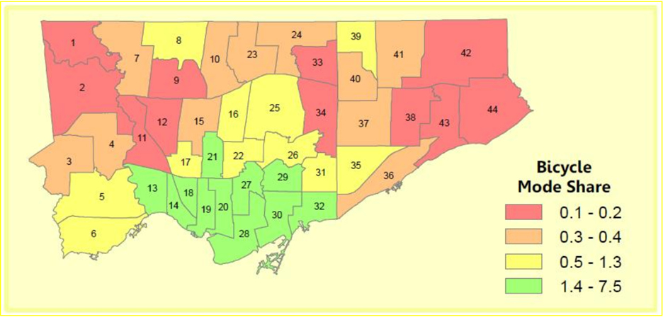
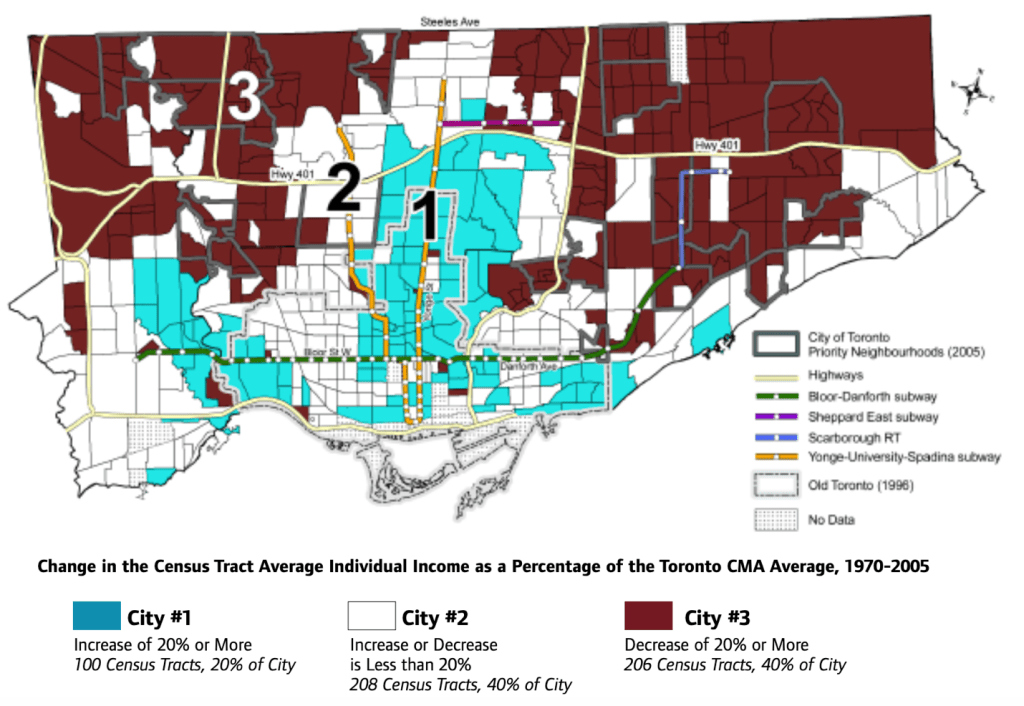
These two maps mirror the connection between lower-income areas and low cycling behaviour. As lower-income areas tend to have poor quality road infrastructure, cycling accessibility tends to be lower.
Not only is there a lack of cycling road infrastructure in these neighbourhoods, they also lack cycling shops. A search of bike shops in Toronto shows that most are concentrated within the downtown core – all of which can be accessed through at least one form of public transit, with most having multiple modes of public transportation in close proximity. It must be noted that there are bike shops and bike resources in areas outside of the downtown core, but they are much sparser and are harder to access if you don’t have a car.
Steven Farber, an assistant professor in the Department of Human Geography at the University of Toronto, outlines that there are significant policy gaps when it comes to equitable transportation and transportation infrastructure.
At the Transportation Equity Summit last year, Farber argued that those involved in the transportation planning process lack substantial standards for making billion-dollar investments, creating inequitable planning projects. These policy gaps must be addressed in order to provide all areas of the city with access to multiple modes of transportation.
However, there are some recent projects giving some underserved neighbourhoods more mobility options. Bike Share Toronto has recently expanded outside the downtown core to run pilots in North York and Scarborough, and the City of Toronto is also working on an autonomous shuttle pilot in partnership with TTC and Metrolinx to connect Scarborough’s Rouge neighbourhood to the Rouge Hill GO station. The Finch West LRT will also improve transit options in northwest Toronto, although its expected completion date is still three years away.
Lots more still needs to be done to improve mobility across Toronto, but by creating equitable transportation projects, lower-income areas around the City of Toronto will have the opportunity to participate in different modes of transportation, reducing their daily costs and increasing overall health and happiness.
Photo by Aleks Magnusson from Pexels